
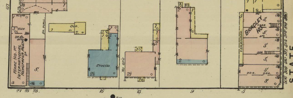
Sanborn 1886 Map:
1879 Bird's Eye View:

5 Elm Street
Status: Extant!
The main façade of this building was on State Street and it will be dealt with there.
Block Survival Rate: 5/6: 83%The main façade of this building was on State Street and it will be dealt with there.
9 Elm Street
Status: Demolished, 1946
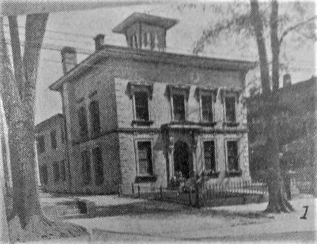
Built For: Leverett Candee, 1851-9
This was one of the most lavish Italianates in New Haven and one of the strangest, since a four bay façade is relatively atypical in the Italianate style. It was built for Leverett Candee, who ran a rubber company. The three right hand bays seem to be more closely grouped than the bay to the left. The façade appears to be of brownstone or marble (it's unclear) and featured quoins at the corners, a lavish cornice with dentils and modillions, a string course separating the first and second floor, and elaborate carved window surrounds, with simpler forms on the first floor (eared moldings) and more elaborate acanthus bracketed pediments on the second. Older photos show that not only was there a balustrade running around the roof, but there was also a balustrade around the tall cupola. After serving as a private club for many years, it was demolished in 1946 for the commercial building that is still there (altered).
13 Elm Street
Status: Extant!
Built For: Charles Nicoll, 1828
A great example of New Haven Greek Revival which follows the typical Greek plan found throughout the city of five bays with a triple window in the center bay, though the low basement is atypical of other examples. The Doric entablature is especially tall to accommodate a large third story with windows. The porch has Temple of the Winds columns and some nice ironwork.
15 Elm Street
Built For: Charles Nicoll, 1828
A great example of New Haven Greek Revival which follows the typical Greek plan found throughout the city of five bays with a triple window in the center bay, though the low basement is atypical of other examples. The Doric entablature is especially tall to accommodate a large third story with windows. The porch has Temple of the Winds columns and some nice ironwork.
 |
| Photo: Wikimedia |
Status: Extant!
Built For: John Cook, 1805
A unique example of Federal architecture in New Haven, this house is distinguished because of its stuccoed façade, a rarity in buildings of this period and was built for John Cook, a successful merchant and captain. The browstone window lintels with slightly splayed forms and the quoins are telling for this period and were uncommon in contemporary New Haven architecture; the Ionic Greek Revival porch may be slightly later. Particularly notable are the windows of the third story on the sides of the building, with two rectangular windows, flanked by quarter circle windows, and topped by a single semi-circular window. These provided light to the third floor ballroom. The dormers are certainly a later addition.
 23 Elm Street
Built For: John Cook, 1805
A unique example of Federal architecture in New Haven, this house is distinguished because of its stuccoed façade, a rarity in buildings of this period and was built for John Cook, a successful merchant and captain. The browstone window lintels with slightly splayed forms and the quoins are telling for this period and were uncommon in contemporary New Haven architecture; the Ionic Greek Revival porch may be slightly later. Particularly notable are the windows of the third story on the sides of the building, with two rectangular windows, flanked by quarter circle windows, and topped by a single semi-circular window. These provided light to the third floor ballroom. The dormers are certainly a later addition.
Status: Extant!
Built For: Imperial Granum, 1877
One of New Haven's few surviving cast-iron buildings, this was designed by architect Rufus Russell. Each level features large segmental arched windows separated by gaudy Corinthian columns. Each floor is separated by a thick entablature with dentils and large keystones. The painting of the building, which has been both gray and brown is appropriate, since cast-iron buildings were supposed to imitate more expensive stonework.
25-27 Elm Street
Status: Extant!
Built For: 1875
Another great commercial building of the 1870s, unlike its neighbor it was constructed of stone and brick. The stone banding and window hoods are beautifully incised with Eastlake ornament and outlined in black brick for added emphasis. The entablature and cornice have been jazzed up with half sunbursts, another Eastlake feature. There is an Italianate cupola on the rear of the building that finishes off the design grandly.


